Connecting with the earth, enriching our senses, observing the witching hour, crowning the summit, pedalling smoothly. Cabanes is the experience of reconnecting with the land through its hiking and cycling trails. Trails for all tastes and levels in nature's embrace.
Hiking in Cabanes
Authentic and rural
Connecting with the earth, enriching our senses, observing the witching hour, crowning the summit, pedalling smoothly. Cabanes is the experience of reconnecting with the land through its hiking and cycling trails. Trails for all tastes and levels in nature’s embrace.
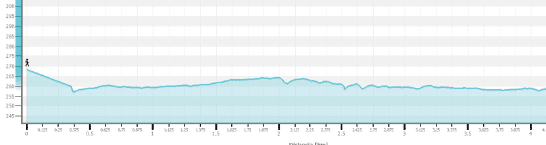
This trail runs through the leafiest part of the Nature Reserve and starts on a dirt track in the direction of La Pobla Tornesa. Upon reaching a turn-off that would take you straight to the summit of El Bartolo, continue to the left along a path that soon starts to descend steeply until you reach a track that will take you back to Les Santes Chapel. A unique environment in one of the oldest geological areas in Valencian territory. You can reach it from the CV-148 road, which connects the towns of Cabanes and Oropesa, in the part closest to Cabanes. The entrance is signposted with an information panel.
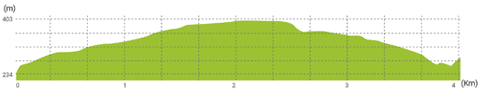
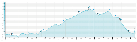
Miravet Castle Trail
DIFFICULTY: EASY
Start: Les Santes Chapel (PR-CV-422)
End: Les Santes Chapel
Distance: 4km
Length: 01:40
Walk 500 m along the road in the direction of Oropesa until you come to a signposted track to the right, which soon turns into a path. As you ascend, you will see the remains of the castle's outer wall and, a few metres further on, the entire set of architectural remains. A route with changing landscapes and historical features on which you will discover the ancient fortress of Muslim origin. You can access it from the CV-148 road in the direction of the Los Madroños Rest Home.
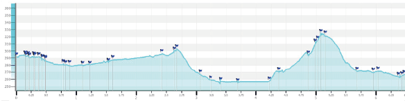
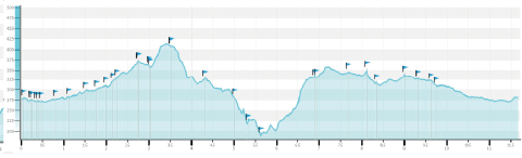
El Bartolo and Les Santes
DIFFICULTY: EASY
Start: Les Santes Chapel (PR-CV-422)
End: Les Santes Chapel
Distance: 9.9km
Length: 06:00
The trail starts in the direction of La Pobla Tornesa, taking you through pine groves and almond and carob crops, up to the highest peak in the Nature Reserve (729 metres), El Bartolo, where you can enjoy the incredible panoramic views of the coast of Castellón and a large part of the inland landscape. On the way back to the chapel, along a signposted track, you can see one of the unique botanical features of the area: the two largest specimens of Quercus cerrioides oak in the province, a species that is rare in Castellón.
Prat de Cabanes-Torreblanca Nature Reserve Trail
Torrenostra
DIFFICULTY: VERY EASY
Start: Torrenostra village centre (south)
End: Torrenostra village centre
Distance: 4.5km
Length: 02:35
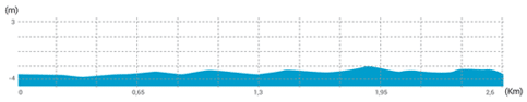
The trail starts in the direction of La Sal Tower and continues along a path that runs parallel to the coast. You will reach 'Gola del Trenc', where the drainage channels flow into the sea. From there, walk along the channels, cropland and the lagoons formed by peat digging. Discover species unique to the area, such as salt grass, and enjoy incredible panoramic views from the top of the viewpoints - a real environmental treasure!
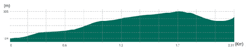
La Sal Tower 1
DIFFICULTY: VERY EASY
Start: Information Centre
End: Information Centre
Distance: 2.5km
Length: 00:45
A signposted trail on which you can enjoy the views offered by the original pebble barrier and discover a flora micro-reserve as well as some of the ornithological species typical of the area. The route begins at the Information Centre, located next to the Torre de la Sal Aquaculture Institute, where you can also discover all the peculiarities of this rich
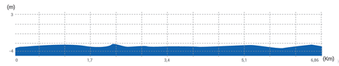
La Sal Tower 2
DIFFICULTY: VERY EASY
Start: Information Centre
End: Information Centre
Distance: 6.5km
Length: 01:40
A signposted path that runs parallel to the coast in the direction of Torrenostra. Discover the fossil dunes, the impressive pebble barrier that runs almost uninterruptedly along the Nature Reserve, on a pleasant walk until you reach a beautiful sandy beach near the ruins of the old carabineer barracks. This trail also takes you into the wetlands on a final stretch that runs through marshes. You will come back filled with Mediterranean sensations!
Trail through Cabanes and the surrounding area
Warning! The trails are not signposted. You can use our wikiloc.org channel to follow the trail safely.
The SLC5 circular trail starts at Plaça els Hostals in Cabanes. It is 6.88 km long and rated very easy. It runs almost entirely on unpaved farm roads, which are easy to follow and walk on. It includes a short stretch of tarmac road and a stretch of mountain path with some stony parts and slightly uneven ground. This trail is suitable for everyone and is especially suitable for people who are not used to walking long distances or on very difficult terrain. It is a trail that can be compatible with healthy exercise due to its short length, ease of movement and accessibility. The type of terrain over which it runs allows the trail to be done both on foot and by bicycle.
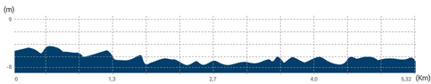
Cabanes Local Footpath – SLC1
DIFFICULTY: VERY EASY
Circular trail
Distance: 5.74km
Desnivel positivo: 32m
Uphill elevation change:32m
Downhill elevation change32m
The SLC1 circular trail starts at Plaça els Hostals in Cabanes. It is 5.7 km long and rated very easy. It runs almost entirely on unpaved farm roads, which are easy to follow and walk on. This trail is suitable for everyone and is especially suitable for people who are not used to walking long distances or on difficult terrain. It is a trail that can be compatible with healthy exercise due to its short length, ease of movement and accessibility. The type of terrain over which it runs allows the trail to be done both on foot and by bicycle.
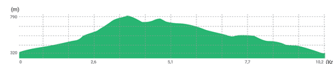
Cabanes Local Footpath – SLC6
DIFFICULTY: EASY
Circular trail
Distance: 12.27km
Desnivel positivo: 329m
Uphill elevation change:329m
Downhill elevation change329m
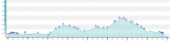
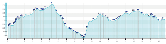
The SLC6 circular trail is 12.32 km long and starts at Plaça els Hostals in Cabanes. It is rated easy. The trail goes through agricultural and forestry land, along unpaved farm tracks, together with stretches of mountain path that are easy to follow and some sections that are somewhat difficult to walk along. There are areas with stony paths and somewhat uneven ground. It includes a short stretch of tarmac road. It is a trail suitable for people used to walking medium to long distances on terrain with low difficulty, with some physical effort. The type of terrain over which it runs allows the trail to be done both on foot and by mountain bike.
Cabanes Local Footpath – SLC9
DIFFICULTY: EASY
Circular trail
Distance: 7.22km
Desnivel positivo: 244m
Uphill elevation change:244m
Downhill elevation change244m
The SLC9 circular trail starts at the same starting point as the castle trail, next to the CV-148 road. It is 6.95 km long and is rated easy. The route goes mostly through forest terrain, to a lesser extent through agricultural land, and there is a stretch of tarmac road. The forest sections are mountain paths that are easy to follow with some sections that are somewhat difficult to walk along. There are areas with stony paths and somewhat uneven ground. It is a trail suitable for people used to walking medium to long distances on terrain with low to medium difficulty, with some physical effort. The type of terrain over which it runs allows the trail to be done both on foot and by mountain bike.
Cabanes Local Footpath – SLC10
DIFFICULTY: EASY
Circular trail
Distance: 13.67km
Desnivel positivo: 231m
Uphill elevation change:231m
Downhill elevation change231m
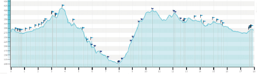
The SLC10 circular trail starts at Plaça els Hostals in Cabanes. It is 13.67 km long and is rated easy. The trail goes mainly through forestry land and along unpaved farm tracks, together with stretches of mountain path that require some attention to follow and are somewhat difficult to walk along. There are some areas with stony paths, uneven ground and a gradient. It is a trail suitable for people used to walking long distances on terrain with low to moderate difficulty, with some physical effort. The type of terrain over which it runs allows the trail to be done both on foot and by mountain bike.
Cabanes Local Footpath – SLC2
DIFFICULTY: EASY
Circular trail
Distance: 8.02km
Desnivel positivo: 146m
Uphill elevation change:146m
Downhill elevation change146m
The SLC2 circular trail starts at Plaça els Hostals in Cabanes. It is 8.3 km long and is rated easy. It goes along unpaved farm tracks and paths that are easy to follow and easy to walk along. There are some short stretches of stony path or slightly uneven ground. It is a trail suitable for people used to walking short to medium distances on terrain with low difficulty. The type of terrain over which it runs allows the trail to be done both on foot and by bicycle.
Cabanes Local Footpath – SLC3
DIFFICULTY: EASY
Circular trail
Distance: 15.22km
Desnivel positivo: 248m
Uphill elevation change:248m
Downhill elevation change248m
The SLC3 circular trail starts at Plaça els Hostals in Cabanes. It is 15.2 km long and rated easy. The full route includes the SLC2 trail, plus an 8.5 km extension. It goes along unpaved farm tracks and paths that are easy to follow and easy to walk along. There are some short stretches of stony path or slightly uneven ground. It is a trail suitable for people used to walking medium to long distances on terrain with low or medium difficulty, but with some physical effort. The type of terrain over which it runs allows the trail to be done both on foot and by bicycle.
Cabanes Local Path – SLC4
DIFFICULTY: DIFFICULT
Circular trail
Distance: 19.26km
Desnivel positivo: 361m
Uphill elevation change:361m
Downhill elevation change361m
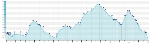
The SLC4 circular trail starts at Plaça els Hostals in Cabanes. It is 18.3 km long and is rated difficult. The trail goes mainly through forestry land and along unpaved farm tracks, together with stretches of mountain path that require some attention to follow and are somewhat difficult to walk along. There are some stretches with stony paths, uneven ground or the need to use your hands to get along. There are also areas with thick vegetation that make it difficult or uncomfortable to walk. It is a trail suitable for people used to walking long distances on terrain with moderate to high difficulty, with some physical effort. The type of terrain over which it runs allows the trail to be done both on foot and by mountain bike.
Cabanes Local Footpath – SLC7
DIFFICULTY: DIFFICULT
Circular trail
Distance: 18.07km
Desnivel positivo: 535m
Uphill elevation change:535m
Downhill elevation change535m
The SLC7 circular trail starts at Plaça els Hostals in Cabanes. It is 17.93 km long and is rated difficult. The full route includes the SLC6 trail, plus a 7.18 km extension. The trail goes mainly through forestry land and along unpaved farm tracks, together with stretches of mountain path that require some attention to follow and are somewhat difficult to walk along. There are some stretches with stony paths with uneven ground or the need to use your hands to get along. There are also areas with thick vegetation that make it difficult or uncomfortable to walk. It is a trail suitable for people used to walking long distances on terrain with moderate difficulty, with some physical effort. The type of terrain over which it runs allows the trail to be done both on foot and by mountain bike.
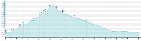
Cabanes Local Footpath – SLC8
DIFFICULTY: DIFFICULT
Circular trail
Distance: 1.3km
Desnivel positivo: 112m
Uphill elevation change:112m
Downhill elevation change112m
The SLC8 circular trail starts at the bottom of the hill that climbs to Miravet Castle, next to the CV-148 road. It is 1.27 km long and is rated difficult. The trail goes mainly through forestry land and is easy to follow, but and somewhat difficult to walk along. There are some stretches with stony paths, with a steep gradient, uneven or slippery ground, and stretches on which you need to use your hands. The trail has a short stretch of tarmac road. It is a trail suitable for people used to walking short or medium distances on terrain with moderate to high difficulty, with some physical effort. The type of terrain over which it runs allows the trail to be done on foot.